Gallery
During the public session, HOOOH advisor and heritage planning expert, Tim Malim, addressed councillors ahead of an agenda item on Inspector Claire Sherratt’s SAMDev modifications.
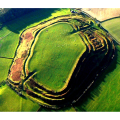
Mr Malim cautioned that despite the Inspector’s decision to keep OSW004 (117 houses off Whittington Road) in the plan, a strong case remains against development. He circulated copies of a recent article in the Guardian/Observer where leading lights in archaeology speak out against development, including the eminent Iron Age specialist Professor Sir Barry Cunliffe, and Dr Mike Heyworth, director of the Council for British Archaeology.
Mr Malim went on to state that a number of clear planning contentions remain, including:
OSW004 is not deliverable because justification for its development was as part of a coordinated scheme - the Oldport Masterplan – incorporating sites at Jasmine Gardens and Oldport Farm that were removed from the SAMDev plan. Mr Malim said that when challenged on this at the Inspector’s hearing, the site promoter responded that it would be making a planning application for all three sites, suggesting there is a planning issue with OSW004 as a stand-alone site.
Also during the Inspector’s hearing, Shropshire Council referred to OSW004 as providing a ‘soft edge’ to Oswestry’s northern boundary. The inference is that it would provide some sort of feathering into the fields north of the town in contrast to the ‘hard edge’ of the current B4580 Whittington Road. The Inspector’s modification, reflecting the Statement of Common Ground between Historic England and Shropshire Council, now states the need for a ‘landscape buffer to create a clear settlement boundary’ between OSW004 and fields. Mr Malim suggested that these offer no benefit when the existing road already serves as a clear boundary while stemming any further urban encroachment into, and loss of, the setting of the hillfort.
Town clerk, David Preston, then read out an email and circulated visuals from Dr George Nash, an archaeologist and HOOOH advisor, raising new concerns that archaeological reports/evidence concerning land at OSW004 have been
insufficiently carried out and selectively used in justifying the case for development. (See statement at end.)
Councillor Chris Stokes voiced his continuing concerns over OSW004, saying that “in view of the information presented before us, it needs to be excluded from the plan.”
This sentiment was echoed by Councillor Alan Davis who proposed a motion, seconded by Councillor and former Mayor, John Gareth Jones, to write to Shropshire Council to underline their opposition. A vote was taken, with nine councillors in favour, one against and two abstaining.
David Preston recorded for the minutes that a letter would be actioned reaffirming in the strongest terms the Council’s full support for HOOOH and requesting removal of OSW004 from SAMDev.
In February 2014 after voting to oppose OSW004, the town council wrote to Shropshire Council asking for ‘a commitment to look to shape planning guidance for the Hill Fort and its surrounds for the future, bringing together interested agencies to formulate a strategy and policies looking into the historical and archaeological protection and promotion of the site.’
HOOOH has briefed and sent documents to a specialist planning lawyer in preparation to make a legal challenge. The group is currently setting up an online fund to accept donations from concerned supporters around the world.
*Additional note: HOOOH says that it is also clear that Shropshire Council has failed to use NPPF paragraph 169 effectively in forming their evidence-base for plan making. This requires that the Council should use information already available to predict the likelihood for archaeological remains in the fields at OSW004, being an essential part of the setting that contributes to the heritage significance of the scheduled monument of Old Oswestry. This is borne out by Dr George Nash’s statement below.
Dr George Nash’s statement to Oswestry Town Council, 1 July 2015
“In collating all the available archaeological evidence and using the necessary heritage guidance (in particular NPPF and Note 3 [2015]), there would be CLEAR indirect impacts on Old Oswestry Hillfort from development at OSW004. Furthermore, there would be SEVERE direct impacts from any potential groundworks in and around OSW004 related to any development, based on geophysical survey evidence and data supplied by the PAS (Portable Antiquities Scheme).
It should be noted that this area is within the working hinterlands of the Iron Age hillfort and, based on the geophysical survey, a number of significant anomalies exist within this area including corralling enclosures, amongst others (see fig 1). I would also suggest that this area has an important Early Medieval (ref Wat's Dyke) and World War I legacy which we know little about.
The County's Historic Environment Record (HER) lists five sites within the area of OSW004 and a further six sites in and around the eastern side of the hillfort (see fig 2). These will be destroyed if development goes ahead. I also notice that an official Walkover Survey has not been conducted which more than likely would identify other sites of historic and archaeological interest. I am surprised that this was not undertaken prior to the geophysical survey.
Fig 1
Excavated trenches at OSW004 largely miss archaeological anomalies.
Red stars signify proposed trenches (9 in total) which were not excavated following the geophysical survey in 2007. The trenching regime was originally for 24 trenches but none were implemented on the western side of the old A5, that is, around Old Port Farm.
In terms of Old Port Farm, the buildings have NOT been looked at by Historic England (EH) and at present they are collectively described as a 19th century farm. This is despite the fact that the farm is on a plan of 1780 and the main farmhouse and outbuildings contain substantial medieval timber-framing.
In summary, the archaeological process to date has been a complete disgrace; the responsibility for this lies initially with English Heritage (now Historic England) and, in particular, Shropshire Council. The evaluation trenching strategy ignores the significance of the area. I am interested to know why all the trenches on the western side of the B5069 (Gobowen Rd) were not excavated, and why strategic trenching was not conducted over clear identified archaeological anomalies within OSW004?
English Heritage and Shropshire Council’s Statement of Common Ground is now out-of-date and contradictory, showing little concern for the guidance rules that English Heritage/Historic England itself expects Local Authorities and the heritage industry to adhere to. I would also challenge that following the public inquiry, the Inspector's report was produced by a professional planner who had little knowledge of the cultural heritage implications of the site and appears to have been led very much by a one-sided account from Shropshire Council.
There is a simple way out of this mess: Shropshire Council should listen to all the arguments against this potential development and gracefully retreat.”