
Richmond and Twickenham set to become more legible for pedestrians
The Mayor and Transport for London (TfL) have announced that the Borough of Richmond upon Thames will be developing Legible London, a unique system of on-street signs, maps and fingerposts designed to make it quicker and easier to walk around the Capital.
The scheme uses 3D representations to give people a quick sense of their bearings and help them locate shops, parks, hotels, landmarks, toilets, Tube stations and other amenities.
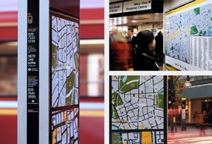
It has already been successfully guiding visitors around the Bond Street area of central London for the past year, as part of a prototype study. Richmond upon Thames has been chosen for funding by TfL as one of three areas in London to pilot the new pedestrian system and specifically to see how the system can meet outer London needs.
Local steering groups are being set up to help develop the design and locations for the signage in Richmond and Twickenham town centres and surrounds.
Legible London will complement the work of Smarter Travel Richmond, a three year, £4.5m programme, funded by TfL, which will start in March 2009. The programme will aim to cut the number of car trips made in the borough in order to reduce congestion and CO2 emissions, which contribute to climate change.
Redundant street furniture and confusing signage will also be removed with the introduction of Legible London. The removal of obsolete signs and their replacement with fewer and more attractive easy to understand maps will reduce visual clutter and make life easier for pedestrians.
Ben Plowden, Director of Smarter Travel at TfL, said:
"Walking is a convenient, enjoyable and healthy way to get around London. It's also often a quick option around half of all car journeys in outer London are less than 2km, a distance that can be walked by most people in around 20 minutes.
"The problem is that London can sometimes be challenging to navigate on foot. Legible London has been designed to address that, by creating a reliable way-finding system that makes it easier to walk in and about London. Its clear and easy-to-read mapping will let people know which roads to take, what landmarks they'll pass along the way and how long it will take them to get where they want to go."
Cllr David Trigg, Richmond Council Cabinet Member for Traffic, Transport and Parking said:
"Being awarded funds to improve our pedestrian signage is a great opportunity for both Richmond and Twickenham town centres. It is also very timely as it will fit into current and planned environmental and highways improvements and our clutter reduction programme."
"Obviously we need to make sure that the signage takes into consideration our unique historic character, and we are setting up local steering groups to assist in the design and location of the signs and to ensure that the signs are accessible for all groups of people."
The Mayor, TfL and the London Borough of Richmond upon Thames are all clear on the need for better pedestrian signage and information throughout the Capital, and are committed to improving local conditions as part of a wider programme to make London a great walking city.
